Belchamp Walter
Belchamp Walter is a village on the Essex Suffolk border.
For more details on the history of the village from the time of the Norman Conquest to the current era.
For information on the parish church of St. Mary the Virgin, Belchamp Walter
Belchamp Walter is famous for the location of Lovejoy's Workshop and the home of Lady Jane Felsham in the '80s TV series Lovejoy.Much has changed in Belchamp Walter, the map below shows what it was like in 1856,
and in 1923
An interesting article from the Halstead Advisor, 1973 describes the village as it was neary 50 years ago. Names of residents of the time are there.
The Chapman and Andre Map of Essex - 1777

The History of Belchamp Walter.
Please also visit my pages on St. Mary's Church and the History of Belchamp Walter..The settlement of Belchamp Walter (Walter Belchamp) was recorded in the Doomsday Survey, William the Conqueror's massive stock-take of his new lands.
From 1066 to the present time some is known about the village particularly after the Raymond family purchasing the Manor in 1611. Prior to that time, in the years between Conquest and the 17th Century, the information is, like a lot of British history a little sketchy.
Before the Norman Conquest, in the years of Edward the Confessor (1042 - 1066), the settlement was under Saxon control.
After the Conquest William either allowed Ulfwine, Ulwine or Ulwin, a Saxon noble to remain as lord of the manor or he assigned it to one of his compatriots that assisted him at the Battle of Hastings. This could have been a member of the Malet Family, William Malet was reported by William of Poitiers as a companion..
The manor was then assigned to the de Veres. Alberic de Vere was related to William the Conqueror but is not found in any records of the Conquest. This Alberic de Vere was Sheriff of Berkshire, chamberlain to William I and resident of Earls Colne was in control of the region. Robert Malet was possibly the first to "hold" Thunderlow but possibly had it confiscated as he "took-up" with Robert Curthose, William's oldest son.
The 16th Century manor house was replaced by the current Belchamp Hall in 1720/1721 by John Raymond III. The manor house was probably built prior to when it "came to" John Wentworth in 1539 and was probably of Vernacular architectural design. A few other such structures still exist in the village.
The photograph of the crossoads shows a view taken from the "Old Bake House" looking West towards the pond. The "Smithy" is on the left and the houses on the other side of the pond are no longer there and were possibly a work house complex.
The crossroads, the pond and the Forge are shown below. The brick wall had a circular structure, possibly the remains of the forge fire pit, behind it. As recently as 2015 you could see this structure which looked like a pond. This has now been redeveloped.

The current village, the cross-roads and duck pond, are relatively modern. I believe that the original village centred around the church and Belchamp Brook, south of what is now Belchamp Hall. The brook and the flood plain berween Belchamp Walter and Bulmer/Gestingthorpe were probably used for farming and possibly the location of the vineyard. The brook had been diverted at one point to serve as a mill race for the water mill that is now Lovejoy's Mill. The water mill was not listed and was converted to a holiday rental in 2009. However, the structure does still contain remnants of the original.
Belchamp Mill
See page on Belchamp Walter, the Water Mill
The Village Sign
The village sign that is to be seen at the pond at the crossroads and designed by villager Nigel for the Millenium celebrations 2001.

The date of 904AD, and its relevance, is yet to be established. There is a date of 940AD, taken from Birch’s Cartularium Saxonicum, (1885-1893)
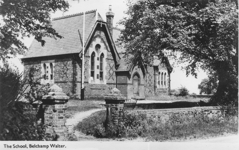
School House
The village Hall

tempusfugit.me.uk is no longer the webmaster of the Village Hall website. The ownership has been transferred to a Village Hall Committee member.
8 Bells Pub
Now a private house. It is now called Bell House and is located on Bells Road, Belchamp Walter.

The pub was named after the 8 Bells in St. Mary's Church.
1923 Map

P. H. Reaney says about Belchamp Walter and its inhabitants/Major dwellings:
Seven Farms
The Seven Farms mentioned by Reaney (Seven Formes) still floods, but not so much at the location that he describes. The road to Foxearth, Temple End, still floods as does Otten Road South of Eyston Hall.

The 1777 Chapman and Andre map shows Goldington, Smeeton and Kitchins. (Kitchen Hill)
Copyright and License
I have reproduced postcards and maps on this on other pages on this website. I have tried to adhere to both copyright and licensing issues. Please let me know if I am in violation and I will remove these images.
This website is totally non-commercial and the Creative Commons SA (CC-by-SA) licence often is valid but in some cases assumed.
March/April 2023 - This page is being updated.
It should be the "entry point" for anyone who is actually interested ib Belchamp Walter, I admit that I have been spending most of my time updating the ancient history of the village and the Wall Paintings in the Church in particular.
Roads
- Hall Road - the crossroads towards the church and hall
- Gestingthorpe Road - From the Crossroads/Duck Pond towards the treatment plant - may have been Poplar Road in the 19th Century
- Bells Road - Soft Road
- North Road - the loction of the Village Hall/New School House
- Green Common
- Chapel Hill
- Yeldham Road, Otten Road, Puttock End - Northwood (North End - now Little Yeldham)
