All about Wickham St. Paul's
Gestingthorpe - Sudbury - Middleton - Twinstead - Little Maplestead - Wickham St. Paul's
Village Hall is available for hire - see website for rental rates.
6 December Craft Fair - was getting a lot of visits leading up to this
Wickham St. Paul's
Wickham St. Paul's is close to Belchamp Walter. This page and website is part of the
History of Belchamp Walter and surrounding area.
Along with Belchamp St. Paul, Wickham St. Paul's have a common heritage in
that they were both "possesions" of the Canons of St. Paul's. It is strange that the Belchamps lost it apostrophe.
Information on this page is taken from a number of sources that are in common with those that were used to compile the backgrounds to other villages in the region.
The starting point here, in common with Belchamp Walter's history, is the 19th Century account of Thomas Wright in his 1831/36 "History and Topography of Essex".
Building on that Georgian perspective information has been added from other sources related to Wickham St. Pauls including that found on the Essex Society for Archaeology & History.
Top
Thomas Wright - 1831/36
This is a transcript from Wright's "History and Topography of Essex".
This and another parish in Essex have retained the ancient Saxon name of Wickham; Wickham and, on account of its appropriation
to the dean and chapter of St. Paul's, this has been called Wickham St. Paul's; the other, belonging to the bishop of London, is distinguished by the appellation of Wickham Bishops.
Wickham St. Paul's extends northward from Little Maplestead, and is six miles in circumference; five miles from Halstead, and
fifty from London. It has a light and exceedingly fertile soil, and some parts of it have been found suitable to the growth of hops.
In Domesday-book this parish is stated to be one manor, containing three hides, except one virgate; and it was taxed according
to this estimate, in the reign of King Henry the First. At the period of making the survey , it had two carucates in demesne,
pasture for four cows and one hundred and twenty sheep , and thirty-two goats; and there was formerly a park here, of three
hundred acres . The dean and chapter were deprived of this estate in the time of the commonwealth , but recovered it at
the Restoration ; it had , however , during its sequestration, fallen into the hands of a greedy agent of the government,
of the name of Cook, who had stripped it of all its valuable timber .
The lands of this parish were held, under the dean and chapter,
by the family of Coe , of Gestingthorpe, from the time of Henry the Fourth to the year 1625. The Strutt family have also formerly held
these possessions; as also the right honourable John Hobart, earl of Buckinghamshire. Mr. Isaac King is the present lessee
and occupier of this estate.
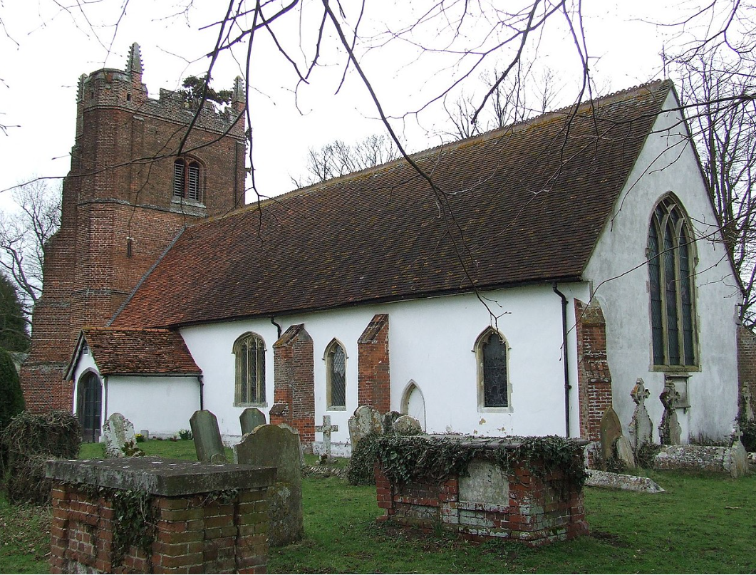
The church is a plain substantial building , in good repair , with a nave, chancel, and large square tower, in which are four bells.
It is dedicated to All Saints. There is a glebe of twenty acres to the living of this church. An annuity of thirty-three shillings,
arising out of three acres of land , is given to the poor of this parish, at Lady Day and Michaelmas . A charitable gift of
five pounds has also been left for the poor ; and the interest is distributed annually .
There is an almshouse on the green for one dweller.
The village green is of considerable extent, and surrounded by houses.
This parish, in 1821, contained three hundred and twenty-eight, and, in 1831, three hundred and eighty-eight inhabitants.
ESAH - Tithe map and information from Essex Place Names
The following is from Essex Place-names Project (Essex Society for Archaeology & History) - James Kemble
The Parish of Wickham St Pauls (in Hinckford Hundred).
Wickham St Pauls Tithe Award (Essex Record Office D/CT 397a), dated 1838, shows a rent-charge of £407 including £7
for glebe payable to Rev. William Key Borton, rector. The whole parish was titheable and measured 1225 acres 24 poles,
of which 1047 acres 3 roods 2 poles were arable, 74a 1r 1p meadow and pasture, 32 acres 22 poles wood, 8a 2r 23p common, 17a 2r 19p gardens, 24a 2r 30 p roads and 20 acres 17 poles glebe. The Tithe Commissioners were William Blaire and JW Buller, the Valuers Henry Coates of 215 Whitechapel Road, Middlesex (surveyor) and Thomas Saville of Sible Hedingham.
The Tithe map (ERO: D/CT 397b) was surveyed at a scale of 20” to a mile and measures 59”x35”. It was countersigned by
Roger Kynaston, Assistant Tithe Commissioner.
Æthelstan, king of the English, confirmed Þicham to St Pauls, London c.961x971. c.995x998 the estate belonging to
St Pauls Hinawicun (the community’s wicham) was required to provide (with Tolandune) two men to man a ship against
incursions (Hart, 1971,1992; Kemble, 2007). In Domesday Book, 1086, the canons of St Pauls held Wicham which they had held before 1066 as a manor for 3 hides less one virgate, with two beehives. Arnold held from Richard son of Count Gilbert half a hide and 10 acres in Wicam which two freemen had held before 1066 under Withgar (Morris, 1983). Canouns Wykham is documented in 1322 (Reaney, 1935). Gelling (1967) suggests that places named wic ham were Roman administration centres (Latin vicus) often close to Roman roads, in this case the road between Gosfield and Long Melford (Margary, 1955).
t. Henry IV John Coe of Gestingthorp was tenant of a parcel of land from St Paul’s. In 1625 George Coe of Great Maplestead (Byham Hall) held 105 acres from the Dean. John Strutt was tenant of part of the demesnes in 1471. In 1768 the lesee was Rt Hon John Hobart, earl of Buckinghamshire, Copy-house was held by Thomas Fenn of Sudbury and Oak Farm by Mr Harington of Totham mill (Morant, 1768).
The church dedicated to All Saints has a 14th century chancel and a brick tower of 1505. Wickham Hall has a five-bay north front, mid 19th century. Catley Cross House, timber-framed and plastered, is 16th century with one-and-a-half storey hall and service end (Pevsner, 2007). The village clusters around the triangular green half a mile south of the church and hall. A tributary of Belchamp Brook forms part of the western boundary ; the brook takes its name from the Belchamp hamlets, a name probably originating from OE belc, bylc, a ridge, on which they lie (Watts, 2004).
The chief farms are named on the Tithe Map. Field- and place-names from the Deed (ERO: D/DSM T62) dated 1361, and from
other documents are shown against the Tithe Award and Tithe Map names.
The Hundred name in Domesday Book was variously Hidincfort, Hidingaforda, Hedingfort etc. which Reaney (1935) translates
‘The people of Heðin’s ford’. The ford is through the River Colne, now bridged beside Hedingham castle, near the moot at
Mustoe (alias Crouch) Green, le Mot(e)stowe, 1262 (Christie, 1926, 1929).
References:
- Christie, M., 1926 and 1929. Essex Hundred Moots. Trans Essex Archaeological Society, xviii(3),
p186 and (4), p294.
- Gelling, M., 1967. Place-names derived from wicham. Medieval Archaeology, 11, p87.
- Hart, C., 1971. Early Charters of Essex. Leicester.
- Hart, C., 1992. The Danelaw. Hambledon Press.
- Kemble, J., 2007. Essex Place-names, Places, Streets & People. Historical Publications, London. p.31.
- Margary, I.D., 1955. Roman Roads in Britain, vol i. Phoenix. p.225.
- Morant, P., 1768. History & Antiquities of the County of Essex, ii, 276.
- Morris, J., 1983. Domesday Book - Essex. Phillimore.
- Pevsner, N., Bettley, J., Buildings of England - Essex. Yale.
- Reaney, P., 1935. Place-names of Essex. Cambridge.
- Watts, V., 2004. Dictionary of English Place-names. Cambridge.